
A much-delayed tale of a multiday backpacking trip around the Copper Ridge loop in the North Cascades National Park – which celebrated its 50th anniversary this year!
Day 1: Hannegan Trailhead to Silesia Camp
8.2 miles by the map
Note:If you want cinnamon rolls on your way from Seattle to, well, anywhere north of Mt. Vernon, I would highly recommend stopping by Calico Cupboard Café and Bakery in Mt. Vernon. They have three or four different kinds of HUGE cinnamon rolls, which looked amazing… and which we didn’t sample (more fools us).
The park ranger who helped us convert our reservation into a permit at the Glacier Public Service Center was super friendly and cheerful. Since he had just finished a loop around Copper Ridge a few days previously, he gave us a bunch of information about the trails ahead of us. He warned us that the parking lot at the Hannegan trailhead was inaccessible to cars, and suggested that we park at the next trailhead down, as parking along the road leading to “our” trailhead might be scarce. Driving onwards from Glacier towards the trailhead, we decided we’d go as far as we could, see if anything was available, and if not, take it from there. We were glad we did! There was a bunch of parking right before the washout that made the parking lot inaccessible, and the next nearest trailhead was two miles back down the road. (No thank you!)
The path from the trailhead to Hannegan Pass runs a long, slow incline up and along the north side of a lovely valley, until it takes an abrupt turn at the pass itself, heading into some steep switchbacks down to the national forest/national park boundary, at which point the view ahead of you also abruptly opens and you get your first look at the mountains and valleys beyond. The only downside with this gentle entry into our hike was the bugs. I got my first experience with blackflies, and… I’m not very good at dealing with blackflies. It turns out.
After the switchbacks, you walk a little ways further on (our first mild snow crossing!) and you get to the boundary, and the sign for the national park, and the first choice of the trail: up and left towards Copper Ridge, or down and right towards the Chilliwack River valley? Up we went!

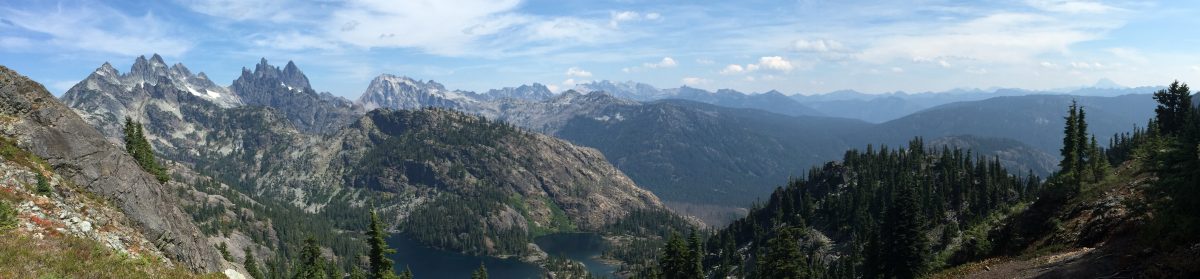
The climb up to the ridge doesn’t seem that bad in retrospect (given what we did later in the trip), but it was enough to challenge me then. Fortunately, the views from the trail south into the rest of the park were beautiful enough to warrant frequent stops! We also started a joking conversation theme called “Would you free-solo that,” where we pointed out objects both actually daunting and ridiculously easy and posed that question to the other.

Up towards the top of the ridge, snow started to be something of an issue. Not for me – my brilliant waterproof Vasque hiking shoes were stellar throughout. But the mushy snowfields were less fun for B, who was wearing some trail runners that have seen velveteen rabbit levels of love. Ah well. At least he had wool socks.
Silesia Camp proved pretty buggy, but with mosquitoes rather than blackflies. Since there was plenty of airflow up there too, we decided to quickly set up our mesh inner tent and make dinner inside, then worry about sorting out the fly and sleeping stuff later. You know those shots in movies, where the main character walks down a hallway inside a prison and the prisoners shake the bars of their cells and yell and reach out through the bars to try to grab at him/her? It felt a little like that inside the tent, with the enormous mosquitos latching onto the mesh and the occasional larger bug zooming by, sounding like a fighter jet in the quiet of the park…

B then did a deeply chivalrous thing. Despite the fact that the mosquitoes liked him a lot more than they liked me… he offered to go find water for us. We’d passed a few places of running water, and knew we wanted to use that rather than trying to melt snow, but the closest one was about a quarter-mile away. And yet he went, so that I wouldn’t have to get back out into the bugs again for a while. My hero, in all seriousness.
By the time sunset started to roll around, the bugs had mostly gone away for the evening. We had been watching the weather shift from inside the tent – seeing the mist billow up on both sides of the ridge, then eddy away – and now we got out of the tent both to put our food/aromatics into the bear locker, and to take some photos. Then we got back in the tent, read for a bit, and went to sleep.

Day 2: Silesia Camp to Indian Creek Camp
11.5 miles by the map
 Day 2 had both the highest and lowest points, both figuratively and literally, of the whole trip (for me, at least). Breakfast may have been slightly over-rehydrated (but still tasty!) eggs and bacon from Mountain House, but the view from our sunny flat space made it a banquet.
That was the theme of the first three-quarters of the day: amazing views, all along the ridge, in all directions, whether from a rocky outcropping above Copper Lake, north towards Canada, or south up the valley that we’d be tackling the next day. We got up to the Copper Ridge Lookout, at 6,260’ the clear high point of our trip. Looking inside, I envied the rangers who got to sleep there; while it wasn’t exactly “all the comforts of home”, it was certainly nice, and the views couldn’t be beat. (As an aside, if you’d like a good read, pick up Philip Connors’ “Fire Season: Field Notes from a Wilderness Lookout.” It’s one of the best nature/outdoorsy books I’ve read.)

We had to cross a fair number of snowfields. One managed to take down both of us, with B tumbling, and me “glissading”, into the grass below it, which fortunately stretched about eight feet from the bottom of the snowfield to the rather sheer drop-off beyond! Neither of us was hurt, either, also fortunately.
 One of the coolest things about the day (other than my rear end after that inadvertent glissade) was getting to see the changing weather. It was never a perfectly clear sky, which was actually to my liking, since I love watching cloud-shadows move across hillsides. But beyond the puffy white clouds above us, we also had occasional mist billow up from below. Even more mesmerizingly, we could watch clouds flow downhill from the peaks across the valley to the south. I don’t remember ever having seen that in real life before, and it was hypnotic.
 So far, high place, high points, right? Well, then things got interesting. Once you round the top of Copper Ridge and start to head east, you also start to head down. And down and down and down. The trail plummets over the course of 13 switchbacks, down to the Chilliwack River below. By switchback 9 or so we were looking forward to the upcoming “enforced icing” of our knees. Enforced, because once you get to the bottom of the switchbacks, you have a pair of river crossings. The first one was only ankle-deep, but the water was cold enough that my feet were tear-inducingly painful within about ten seconds. For the second crossing, by searching around for a good place (which involved pushing our way through some devil’s club), we were able to drop in from a huge tree that had fallen along the bank, whose massive root system upstream worked to slow the river through the deepest part of our ford. Despite all that, and despite that the deepest part was only about six or seven feet wide, six or seven feet of hip-deep snowmelt was plenty enough. Unfortunately, that was followed by a further forty-odd feet of ankle-deep diagonal crossing to get back to where it looked like the trail continued on the other side.
Now we hit the psychological low point of the trip for me. The connector “trail” that we needed to take to hit the main trail back up the river valley…wasn’t really there. We figured that out after about twenty minutes of poking around in the riverwash area, occasionally having to cross little side-streams of the main river and clambering over a lot of deadfall. Finally, thanks to B’s phone GPS, compass, and maps, we determined that the main trail was about a quarter-mile thataway.
Unfortunately, “thataway” was a thicket of devil’s club taller than my head.
Not fun. And my state of mind didn’t help. I was very tired, hungry, and rattled, feeling lost, and aware that it was late and that the sun would be setting sooner than I’d like. Had I been there by myself, I would have been panicking, no doubt about it, and knowing that somehow contributed to my disquiet. B’s presence and calm kept me to just “very nervous,” but when we finally hit the main trail and got to and set up camp, I was jittery from adrenaline for a while longer.
So yeah, plus another thousand to B for that. I honestly don’t think I could have done it without him.
Day 3: Silesia Camp to Graybeal Camp (with loop up to Whatcom Pass and back)
10.9 miles by the map
Our original itinerary had us booked to stay at the campsite near the top of Whatcom Pass on our third night. But partway through day 2 I had proposed to B that we alter things somewhat. We had seen very few other people in the park, and knew that the various campsites weren’t full. So I suggested we brave the potential censure of the park rangers should our change be discovered, and set up camp at Graybeal campsite, at the base of the climb to Whatcom Pass. (Since we were doing a lollipop route, we’d be coming back down past Graybeal anyway.) Then we could put our cameras and some water and snacks into the little, light daypacks we had each brought, hike up to Whatcom Pass, savor the view, and then come back down to Graybeal. B thought that sounded like a good idea.

Getting back down into the Chilliwack river valley brought us into lush shrubbery. There were miles where the trail was barely discernable under our feet – where pathfinding was more about sensing our way forward by finding the path of least resistance with our toes, rather than actually being able to see where the trail went. When we reached a creek crossing we stopped for breakfast, since it was the first clear space we’d come to since leaving camp a couple of miles previously. And here we reached B’s psychological low point for the trip.
We’d both chipped in for our food supplies. B had contributed a couple of dehydrated huevos rancheros packages that he had sitting around, and we pulled one out for this breakfast. Only it turned out that he’d never read the instructions on the packages. Unlike most dehydrated backpacker meals, these called for adding cold water and then cooking the eggs on a stove. We didn’t have the means to do that. So we treated them like we had other meals: added hot water, stirred them up and sealed the container, and let sit for a while. It didn’t really work. I mean, I’m pretty sure the eggs ended up sufficiently cooked – neither of us got sick – but we basically ended up with a hot egg slurry with the consistency of runny grits. Flavored like… well, B says Doritos, and that’s close enough. I ended up eating most of it, because B just Couldn’t Even.
Much of the mouth of the creek that runs past the Graybeal campsite had obviously seen a lot of flooding earlier in the season – a bunch of gullies and washes with rocks and downed trees and no clear path. Took us a while to find our way through; we were probably misled a few times by previous hikers’ rock cairns, and probably contributed our own, similar confusion for later hikers. But we got there in the end.
When we got to the sprawling Graybeal campsite, we scouted around for a place to pitch our tent, and ended up in the horse camp, by the creek. It meant a long walk to the toilet (we couldn’t find the one for the horse camp and had to walk to the more-inland hikers’ campsite), but it also meant easy access to water, and the sound of the creek to lull us to sleep.
After we had a bit of a break and some snacks, we set out on the loop up to Whatcom Pass. It quickly became clear that we had chosen exactly right when we decided to leave the majority of our gear below. The trail up to Whatcom was in places the most precarious of the whole trip – a narrow trail with overhanging plants on one side and a pretty steep drop-off on the other, along with a couple of spicy creek crossings. And the up. All in all, I wouldn’t have wanted to do it with a full pack!


We could see across the valley to the glacier at the top of the other side. It was the first time I can remember having seen in real life that ice blue color that glaciers and icebergs get! Pretty cool. We also had a bit of a chat with a pika who was peeved at how close we got to its den. And eventually the trail leveled out and we arrived at Whatcom camp, which should have been our home for the night. Thank goodness it wasn’t.
Whatcom camp was mosquito city. The air was literally blurry with them. It was f***ing miserable. We sat for a minute to catch our breath before the last push up to the pass itself (Whatcom camp is a little below the pass), but were soon driven to move on. It was more or less okay while we were moving, but once we got to the pass, where we would have liked to have stopped and enjoyed the view into the heart of the park… bleah. We basically just took a few photos – I found it hard to get any that didn’t have bugs in front of the lens, no joke – and then got the hell out of there. As we lost altitude we lost the bugs too, and by the time we got back to Graybeal we only had one or two.

We made dinner and got ready for the night, and I went out to the creek and enjoyed the sunset views back up the valley towards Whatcom. Then we crashed hard.

Day 4: Graybeal Camp to Hannegan Trailhead
14.1 miles by the map
Our itinerary was originally for four nights in the park. The bugs very quickly (like, partway through day 1) got me thinking about alternatives, though, and I had suggested the Whatcom/Graybeal switch to make getting out of the park after three nights possible. Adding the six miles up and back from Whatcom to day 3 meant that we “only” had about fifteen miles left – from Graybeal back to the trailhead – which was doable in a day. Doable, but not fun.
Still the right choice, though. We got to the Copper Creek campsite – where we would have been spending the night – midway through the day, and while it was fine, there was no particular reason to want to stay there. No creek access, no views.

A highlight of the day was the novelty of using a hand-drawn cable car to cross the Chilliwack again. We each went separately, though we could have gone together, because come on, how many times am I going to have the opportunity to do something like that? It was humblingly difficult. The car was made from extremely sturdy metal (which is good!) and so it weighed quite a lot by itself. I started off pretty confidently, but by about halfway across the river I was changing my pulling method on almost every pull, just trying to keep moving. I am not nearly as fit as I occasionally think I am. ::laughing::
Truthfully, once we got across the cable car crossing, most of this day blurs together. I was in the same frame of mind I get into towards the end of marathons, where I am basically wholly focused on finishing and have little energy left for anything extraneous. I had to be, because this day involved – surprise surprise – a lot of climbing. And then, once we’d left the national park and were in the last five or so miles to the car, a lot of descending. We also weren’t carrying enough water, and the “long, slow incline” from the way in turned into a long, slow, very hot and dry decline on the way out, with the full sun beating on us all the way along the unshaded south-facing trail. What kept us going, apart from the need to be done? The thought of the bag of Trader Joe’s “Giant Peruvian Inca corn” that we had waiting for us in the car!
In conclusion: I would do the Copper Ridge loop again. No question at all. I might do it counter-clockwise next time, so that long set of switchbacks was an uphill as opposed to a downhill – might be easier on the knees that way. And I don’t think I’d bother with going up to Whatcom Pass, unless I were planning to cut through the park. But the ridge itself was astoundingly, engrossingly beautiful, and yeah, I’d go back. I will go back.
Hike rating: 5 out of 5 stars, bugs and devil’s club notwithstanding. A trip I would recommend to anyone with the ability to tackle a multi-day, occasionally difficult hike. Seriously: go.
